Keressétek a Csúcsrajárás alkalmazást a Google Playen!
Túráink közül
Mátraháza - Sirok
(2014-06-09)
Mátrai kéktúrázás
Mostanában
Répáshuta kirándulás
(2024. február 13.)
Õszi kirándulás a Déli-Bükkben Répáshuta környékén
Lillafüred kirándulás
(2024. február 13.)
Körtúra Lillafüred-Felsõhámor környékén barlangokkal, forrásokkal, kilátókkal.
Kasprowy Wierch
(2024. január 30.)
Nyári túra a Lengyel-Tátrában a Gáspár-csúcsra
Lorenz-hágó
(2024. január 30.)
Átkelés a Lorenz-hágón a Magas-Tátra szlovák oldalán
Morskie Oko
(2024. január 30.)
Körtúra a Lengyel-Tátrában az Öt tó-völgyében és a Morskie Okonál
Hochschwab
(2024. január 30.)
A Hochschwab hófehér dolomitsziklái
Vereda da Ponta de Sao Laurenco
(2023. október 5.)
Madeira II - Vereda da Ponta de Sao Laurenco
Levada das 25 Fontes
(2023. október 4.)
Madeira IV - Levada das 25 Fontes
Pico Ruivo
(2023. október 4.)
Madeira V - A Kõris-hegyrõl a Kékesre
AK: Körösladány-Dévaványa
(2023. október 3.)
Rövid, de annál unalmasabb kéktúra az Alföldön

Hocher Sonnblick

Magashegyi túra
A leírást készítette: feherb
magyar english 
Idõpont: 2005. július 17.
Indulás: 9.00 - Kolm Saigurn
Érkezés: 20.30 - Kolm Saigurn
Résztvevõk: feherb, krichard, natasa, szabola
Túraparaméterek
A túra hossza10 km
Szintkülönbség1510 m
ÚtvonalKolm Saigurn -> Naturfreundehaus Neubau -> Rojacherhütte -> Sonnblick, Zittelhaus -> Rojacherhütte -> Naturfreundehaus Neubau -> Kolm Saigurn
HelyszínOsztrák Alpok
Legmagasabb tengerszint feletti magasságHoher Sonnblick - 3106 méter
The weather turned out quite good for this day, there were very few clouds in the sky. Only a few cumulus clouds wrapped the mountain-tops, but meant no harm. It took 9 EUR to get up to the parking lot, this was the fee to be paid at the Mautstelle. We didn't bother with it, 'cause it was well worth it. We tried to draw the conclusions from our previous hikes, so we measured the length, steepness of the path and also brought a lot of water: we carried 6 litres, only the two of us.


One house of the village
Waterfall
The village of Kolm-Saigurn is 1600 m above sea-level and consists of only a feew houses from which two is a tourist lodgings. You could easily see the top of Sonnblick, you could see the meteorological station at the top. There are three cable-ways going up but none of them carries tourists. They carry only cargo to two huts and the meteorological station. The feeling was the same as the day before: snow-covered mountain tops, below them waterfalls. As krichard advised we did not go fast, took it slow and steady, the same way as the day before, we with Natasa a little bit behind, but szabola and the others
always waited for us.

Resting
Krichard
Somewhere the path was not too steep
Because we started our hike quite high up, we quickly reached the tree-line. From here there were just rocks, smaller grass and flowers covering the ground, and as we got even higher the number of flowers were getting less and less. The first part until the tourist hut at 2100 metres about sea level was quite steep. There were several possibilities to get to this hut but we chose the shortest and also the steepest. This is where I drank first, had almost drunk 1 litres in one go. We also had to stop near a cow herd because one of them was standing in our way. We told him to leave the path but it was only in vain. Finally we were the ones who had to leave the path but only for a short while to get around the animal.

We arrived to the first Hütte in quite a good time, we sat down and ate something, had some chocolate and collected the strength for the next phase. We could get some water from melting snow, although it's true that it is not as good as mineral water. After about 20 minutes of rest we set off. First we were going in level and also descended a little bit, then we had to cross a bridge over a small but very fast creek. This is where we first got a glimpse of the glacier's lower end leading to Sonnblick. From below the white snow we could see the grey ice blocks.
Detritus
Krichard and szabola
Our way, of course, did not go that direction, we ascended on a rocky hillside. This was not as steep as the road to the first Hütte. The next tourist hut was at 2700 metres, until we reached it we only stopped once for a short time to drink and have a rest. We could see that marmots are living under the rocks. Looking back we could see the hut we just left, and farther deep down sometimes the village also faded into view. We were doing quite good, I expected a lot worse. We soon noticed that the foot of the glacier that we had had to look up to a few minutes ago was not getting below us. The rocks beside the road became bigger and bigger.
69
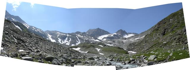
Panorama about the valley of Vogelmaier-Ochsenkarkees glacier


A lonely warrior in the empire of stones
Valleys with snow
The "snow stripes" across the road became also bigger and more frequent and we had to cross two smaller glaciers as well. We had to go about 50 metres through them upwards and then the same downwards at the other end. Between the two glaciers we found a heap of rocks and a pulviometro on the top of this rock pile. This is where the real "very alpine environment" started. It is true that we had already met rocks and snow but this is where we got real close to the peak. The rocks became so big that the road could not be seen among them, and where there were no rocks there was snow. The second Hütte at the height of 2700m was also built in between to huge rocks. We ate here and also fed the Hütte's dog.

At 3000 metres altitude
Scharek in background
The path was the same; the red lines and circles on the rocks showed us the road. The rocks were quite steady and fixed although there were some that moved a little when you stepped on it. There were smaller ones with about 10cm in diameter and there were also ones with over a metre in diameter. Below us we could see the Vogelmaier-Ochsenkar glacier's snowy surface.

The path lead along the ridge paved with rocks, as szabola already pointed it out. But we also saw foot-marks in the snow at the top of the glacier, and they also lead upwards. We decided to take the this way, it seemed easier to climb in the snow than on the rocks.
Rocky terrain
Upper part of valley of the glacier
And descending from the top it would surely be quicker. Szabola went first he made the track for us. We stopped two more times on the snow-filled mountains where we would climb on the top of a rock and sit there.

We didn't know how much was still before us, because we couldn't see the peek. There was a smaller hill before us and that hid it.
Above the sight with 1500 metres
We were talking about turning back if we still couldn't see the hut after the hill. Szabola already saw the antennas of the hut when a cloud suddenly covered the peek. The wind began to blow. And when finally the cloud slipped off the peek the house was right there before us, almost as if we could touch it with our hands.
Panorama at 3000 metres altitude with hikers on the left side of picture

It took about 10 minutes climbing in the snow and we reached it. In the hut we ate a hot soup, and started or descent at half past four. We took some photos of us in the restaurant and also outside with the Großglockner in the background. Szabola's memory card got full so we could only take photos with our camera.

We did not sweat on the top, that day it was only about 7 degrees Celsius as a maximum temperature. The record was 15, so it was not surprising. In the hut we could also read these data on a board. So coming out of the house we had to dress up. We took off these pieces one by one as we got lower and lower.
Our group
The last photo about the summit
We did not search for new adventures but descended the same way we climbed up. I was a clumsy where the rocks were in the snow covered slopes, and Natasa where there were a lot of rocks. But we arrived back in quite a good time. Although there were three stages where we had to go upwards a bit: twice when crossing the glacier, and once just by the first hut. We found these stages quite tiresome after the long descending. Because of the big mountains around us we descended in shadows and this is where I first felt that my hands, neck, my face and even my ears got very sunburnt. We could also see the outline of my sunglasses on my face.